Purbeck is a district of Dorset that takes its name from the peninsula known locally as the 'Isle of Purbeck'. This sixty square mile chunk of land jutting into the English Channel is bordered on three sides by water and, although not actually an island, has an insular character which is largely due to its geography.

A ridge of chalk from the Cretaceous period known as the Purbeck Hills runs along the peninsula from Ballard Down, a National Trust nature reserve north of Swanage, managed for its calcareous grassland habitat, through Corfe Castle and almost to East Lulworth, a hamlet consisting of 17th century thatched cottages. East Lulworth is relatively low-lying due to a break in the cliff that occurs at Arish Mell, while to the north is Luckford Lake, a small stream feeding into the River Frome, which in turn runs into Poole Harbour. In the past the low-lying land would have been very boggy and difficult to cross in winter, hence the 'Isle' of Purbeck.

There are a number of Iron Age, Roman and Saxon archaeological sites to be found on the isle of Purbeck. Nine Barrow Down, for example, takes its name from the nine barrows (stone age burial mounds) that have been found along this ridge on the northern side of the Purbeck hills while Flowers Barrow, near Kimmeridge in the south, is an Iron Age hill fort built 2500 years ago, a part of which has been lost to the sea thereby dramatically demonstrating the effect of coastal erosion.
The first settlement in the area would have been at Wareham. Easily reached by road and rail, today’s town forms an ideal base for exploring the Purbeck coast. Wareham’s accessibility attracted regular raids throughout history, especially from the Vikings, and it was eventually captured by King Canute in 1016. Raised earthen walls were built around the town for protection and today these walls are a haven for wildlife and enclose a thriving market town with a Saxon street plan and more than 200 buildings of historic and architectural interest.

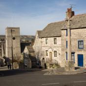
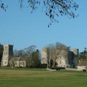
The nearby Corfe Castle represents another attempt to defend the area from marauding armies. Built in a gap in the Purbeck Hills this ruined castle dates back to the 11th century. It is now owned by the National Trust, who are currently attempting to restore it. The village of Corfe Castle, built in the gap below the ruins, is a picturesque affair and attracts many visitors each year.
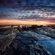
The Purbeck coastline is part of the ninety-five mile stretch known as the 'Jurassic Coast', named England’s first natural world heritage site in 2002 because of the unique insight it offers into 185 million years of the Earth’s history. The Purbeck Beds are an internationally important record of the evolution of mammals at the beginning of the Cretaceous period, and a total of more than 100 different vertebrate species have been identified from fossils. The Purbeck limestones are also famous for dinosaur tracks, the most significant of which are at Keat’s Quarry, where footprints more than a metre in diameter were discovered in 1986.

The more recent social and geographical history of the area is inextricably bound to its complex and interesting geology. Large deposits of Purbeck Ball Clay in the north give way to parallel strata of Jurassic rocks where the land meets the sea, including Portland Limestone and Purbeck Marble, a very hard limestone that, although it is not strictly marble, is capable of being polished. The Purbeck Hills, meanwhile, are part of the Southern England Chalk Formation which includes Salisbury Plain, the Dorset Downs and the Isle of Wight and gives rise to some of the most spectacular cliff scenery in the whole of England. The cliffs contain a fascinating variety of unusual landforms such as Old Harry Rocks, impressive chalk stacks located directly east of Studland, and possibly named after Poole’s famous pirate, Harry Payne, who used to hide his contraband nearby.
Purbeck Marble, like Portland Stone, has been in great demand over the centuries. Many of England’s more famous cathedrals are decorated with Purbeck Marble and much of London was rebuilt in Portland and Purbeck stone after the great fire of 1666. This mining activity led to a number of cliff-edge quarries, the remains of which can be seen at Tilly Whim. These are typical old stone quarries right on the cliff edge called after a special type of wooden crane used to load stone onto boats, known as the ‘whim’. The nearby 'Dancing Ledge' offers another example of man’s influence on Purbeck’s landforms. A massive piece of stone was cut out of the cliff and shipped to Kent in order to construct Ramsgate Harbour, leaving behind a flat ledge the size of a ballroom dance floor.

Purbeck Ball Clay has also played a part in the history of the island, although the principal ball clay workings were in the area between Corfe Castle and Wareham. The much-visited Blue Pool on the Furzebrook Estate between Corfe Castle and Wareham is testimony to this former activity. The pool started life in the early 17th century as a chalk pit and has become famous for its intensely blue colour, which is due to tiny particles of clay that are suspended in the water and defract the light. The pool is set in 25 acres of woodland and was made a SSSI in 1985 due to the large numbers of rare plants and animals in its vicinity including the green sand lizard. Quarrying still takes place in Purbeck, and both Purbeck Ball Clay and Purbeck Marble is now transported from the area by road.
One of the entrepreneurs responsible for putting Purbeck stone on the map was George Burt. Burt was a member of the family that started the construction firm 'Mowlem', and in 1862 he used some of the money he’d made from mining Purbeck stone to buy 80 acres of land around Durlston with the intention of turning it into a high-class tourist complex set in a public landscape. The project failed but many of his public works remain, notably the splendid Victorian folly of Durlston Castle, looking out to sea from the spectacular Durlston Head, and the Great Globe, a testament to the Victorian world-view, which was made in Greenwich in fifteen sections, weighs forty tonnes and survives as a tourist attraction today.

Some of the land was taken over by Dorset County Council in 1973 and made into Durlston Country Park, a haven for plant and wildlife, the downs and meadows around Durlston are rich with wildflowers, birds and butterflies and the south-facing limestone cliffs are host to an important seabird colony and nesting peregrine falcons. In season the Durlston Visitor Centre shows live video coverage of the seabird colony and sounds are relayed from a hydrophone from the seabed in Durlston Bay.
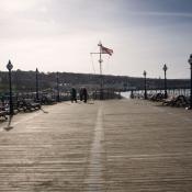
The rise of tourism during the Victorian era led to the growth of some of the small towns and villages in Purbeck, notably Swanage. Only ten kilometres south of Poole, Swanage was a small port and fishing village until the Victorians developed it as a seaside resort. The 19th century wooden pier survives today and is home to sightseeing and angling boats and the ferry to Brownsea Island, a peaceful island of woodland, wetland and heath owned by the National Trust and famous for being the birthplace of the guides and scouts. There is a Scout and Guide Heritage centre on the island as well as the Baden-Powell Outdoor Centre. Brownsea Island is first and foremost a haven for wildlife including red squirrels, peacocks and deer. Swanage is also home to the six mile long Swange Railway. This steam railway originally opened in 1885 and runs past Corfe Castle to the town of Norden.

North of Swanage the sandy beaches of Shell Bay and Studland Beach are hugely popular with sunbathers and Studland’s three miles of golden sand includes the National Trust’s only designated nudist beach.
Studland village is home to a fascinating Norman church, which is just one of a number of interesting churches on the peninsula, perhaps the most famous of which is situated on St Aldhelm’s Head, a remote piece of cliff also called St Alban’s Head and belonging to the Encombe House estate. St Aldhelm’s head is the site of one of the oldest chapels in England, built on the top of a 300ft cliff top with views along the Purbeck Coast. It’s a mystery why a chapel should be built in such a remote location and the fact that one of its popular local names is the Devil’s Chapel suggests, perhaps, a more sinister history.

Encombe House, on the western side of the peninsula, was bought by merchant banker Charles Mcveigh in 2002 for 16 million pounds. The estate includes St Alban’s head and Chapman’s Pool, a small and relatively inaccessible cove at the bottom of 400ft high cliffs, popular with those who relish the solitude of a beach upon which there is nothing but fishermen’s huts.
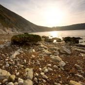
Along the coast from Chapman’s Pool is Worbarrow Bay, a wide, shallow bay just east of Lulworth Cove. Worbarrow Bay, which exposes a sequence of cretaceous rocks from the chalk of the west to the Purbeck Beds in the east, is arguably home to one of the best sections of the Cretaceous in Europe. It is owned by the Ministry of Defence and only accessible when the Lulworth army firing ranges are open.

The Ministry of Defence have played a significant part in Purbeck’s recent history, most notably in the case of Tyneham, a ghost village commandeered by the War Office in
1943, along with 30 square kilometres of surrounding heathland, for use as a firing range for training troops. This temporary measure became permanent in 1948 when the army placed a compulsory purchase order on the land and village and it has been used for military training ever since. In 1975, following sustained lobbying, the village and footpaths were opened to the public at weekends and throughout August and today, although the Elizabethan Manor House was pulled down in 1967, the church and schoolhouse remain intact and are preserved as museums. The absence of farming has allowed the land to become a haven for wildlife.